J. E. Morrison
Space Telescope Science Institute, 3700 San Martin Drive, Baltimore MD 21218
ST ScI has digitized Schmidt plates of the entire Sky. Due to the massive volume of data involved (a total of about 600 Gbytes) the scans have been compressed by a factor of 10 and are made available in the form of 100 CD-ROMs. Software to give the astronomical community access to these scans is being developed by the STSDAS and Guide Stars groups at ST ScI.
The northern-hemisphere data are from scans of the E plates of the National Geographic Society -- Palomar Observatory Sky Survey (NGS-POSS) obtained using the Oschin Telescope on Palomar Mountain. These plates are deep 103a-E exposures obtained through a red plexiglass filter. The southern-hemisphere plates were obtained using the UK Schmidt Telescope while it was operated by the Royal Observatory Edinburgh (ROE). These are deep IIIa-J exposures obtained through a GG 395 filter. The scans were made at the Space Telescope Science Institute using the scanning microdensitometers, which are described in Lasker et al. (1990). A pixel size of 25micron with a 50micron apodized aperture was used throughout.
The original plate images were composed of 14,000 by 13,999 pixels (a pixel is 1.70 arcseconds square). To allow fast access to any portion of the plate, the image was divided into blocks of 500 by 500 pixels that were separately compressed by a factor of ten. Experiments to study the degradation of astrometry on the compressed images compared to the original image were performed by White et al. (1992), who concluded that the astrometry is hardly affected by the compression for modest compress factors (up to about a factor of 20).
The software to read the compressed images is provided with the set of CD ROMs and is also a new task in the GASP/STSDAS package called getimage. In the getimage software the user specifies the region of interest. The software then accesses the data, decompresses the scans and returns the data in a form of a photographic intensity as a function of x and y plate pixel coordinates.
New tasks are being added to the GASP package that will allow the user to manipulate this data. At this time these tasks use the original plate parameters produced by a single global model reduction of the plates. In the foreseeable future the astrometry will use a more sophisticated method.
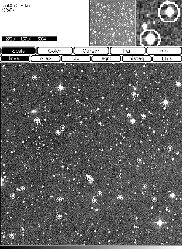
Figure: An image from the Digitized Sky Survey: center (0.h 0, -89.o 0),
and size: 0.o 2. Produced by getimage and dss_targets tasks.
Getimage was used to extract the data, while dss_targets was
used to display the image,
search the Guide Star Catalog for stars in the region, and then plot
white circles around the GSC stars found in the image.
Original PostScript figure (738 kB)
I would like to acknowledge Jeffrey Hayes, Brian McLean, and Jesse Doggett for their scientific assistance.
White, R. L., Postman, M., & Lattanzi, M. G. 1992, Digitized Optical Sky Surveys, 167