Determining geographic longitude and latitude used to be one of the main tasks of practical astronomy in the past. Whereas the basic principle of geographic positioning remained unvaried throughout the centuries, application fields and observation techniques altered thoroughly. In geodesy, the application of celestial position determination changed during the last decades. Celestial methods used to be the only way to determine geographic positions on the Earth's surface until modern satellite systems like the Global Positioning System GPS (e.g., Seeber 2003) took over this traditional task of practical astronomy. Today, classical celestial positioning methods are applied in geodesy for economic and high-precision gravity field determination using modern transportable instruments like digital zenith cameras (e.g., Hirt & Buerki 2002).
The aim of this paper is to introduce the digital zenith camera system TZK2-D (Transportable Zenith Camera 2-Digital) developed at the Institut für Erdmessung, University of Hanover as an efficient state-of-the-art instrument for the astronomical determination of geographic longitude and latitude with an accuracy of 0.2 seconds of arc.
Photographic zenith cameras, developed at Universities in Europe in the 1970's and 1980's (e.g., Wissel 1982), have been applied to the local and regional determination of the Earth's gravity field in many geodetical projects in countries all over Europe and America. Compared to standards of today, these analogue instruments are inefficient since analogue data acquisition and the partly manual data processing required high efforts regarding time, manpower and consequently costs. In recent time, the availability of digital image sensors (CCD) at reasonable prices initiated the development of a digital zenith camera system in Hanover (Hirt 2001, Hirt & Buerki 2002). Compared to classical photographic zenith cameras, this automated instrumentation is a fundamental improvement in terms of automation, real-time capability, accuracy and efficiency.
The basic difference between satellite-based and astronomically determined
geographic coordinates is as follows. Geographic coordinates determined with
GPS refer to the ellipsoid as a simplified geometrical model of the Earth.
Hence, they are called ellipsoidal latitude ![]() and longitude
and longitude
![]() . Geographic coordinates determined with astronomical
instruments such as a zenith camera are called astronomical
latitude
. Geographic coordinates determined with astronomical
instruments such as a zenith camera are called astronomical
latitude ![]() and longitude
and longitude ![]() . They define the local plumb line
and depend on the gravity field of the Earth in contrast to ellipsoidal
coordinates (cf. Hirt 2001 or Torge 2001). Hence, astronomical methods of
geographic positioning can be used for the determination of the Earth's
gravity field, a basic task of geodesy.
. They define the local plumb line
and depend on the gravity field of the Earth in contrast to ellipsoidal
coordinates (cf. Hirt 2001 or Torge 2001). Hence, astronomical methods of
geographic positioning can be used for the determination of the Earth's
gravity field, a basic task of geodesy.
Considering an arbitrary point at the Earth's surface, its astronomical and ellipsoidal coordinates are usually not identical. The differences are called deflections of the vertical and they reflect anomalies of the Earth's gravity field, caused by inhomogeneous mass distribution. Deflections of the vertical vary between a few seconds of arc in rather flat regions up to a maximum of approximately one arc minute in mountainous areas. More detailed information on this subject can be found in Torge (2001).
|
|
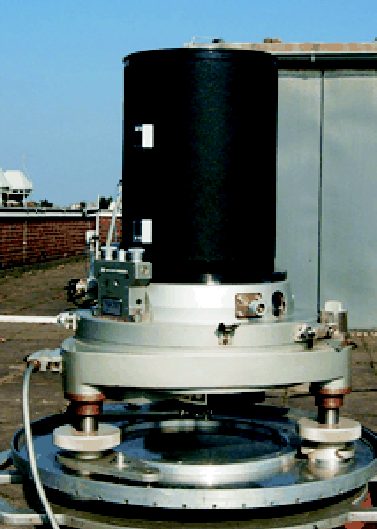
A lens type Mirotar by Zeiss is used as optical component with an aperture of
about 200 mm. It achieves 1020 mm focal length by shortened architecture
similar to Maksutov Cassegrain. A CCD camera KX2E by Apogee used for image
data acquisition is located in the focal plane. The CCD's array with a size
of
![]() pixel corresponds to a celestial area of
pixel corresponds to a celestial area of
![]() minutes
of arc. The CCD camera is equipped with an electronic shutter for exposure
time control using a logical TTL signal. In contrast to other telescopes,
the zenith camera is a non-tracking system. Therefore, the instrument's
limiting magnitude of 14.0 is achieved within short exposure intervals
between 0.2 and 1.0 seconds of time.
minutes
of arc. The CCD camera is equipped with an electronic shutter for exposure
time control using a logical TTL signal. In contrast to other telescopes,
the zenith camera is a non-tracking system. Therefore, the instrument's
limiting magnitude of 14.0 is achieved within short exposure intervals
between 0.2 and 1.0 seconds of time.
Celestial position determination requires the exposure epochs for longitude determination. For high-precision time keeping, a GPS equipment consisting of antenna and receiver is connected to the electronic shutter of the CCD camera via a hardware link. Utilizing the TTL signal, the epoch of every exposure is marked at the GPS time scale.
A pair of electronic tiltmeters of type High Resolution Tiltmeter (HRTM) by Lippmann is used in orthogonal orientation to level the zenith camera. Minor deviations between the zenith camera's optical axis and the plumb line are measured during exposure and corrected in order to get reference to the plumb line. The tilt measurement is done with an accuracy of approximately 0.05 seconds of arc.
An industrial computer for device steering, data acquisition, data storage and real-time data processing in combination with a wireless display for visualization and remote system control completes the digital zenith camera system.
The processing chain starts with the astrometric reduction of the
observations. Using image moment analysis, the extraction of imaged stars is
quickly performed achieving an position accuracy of ![]() arc seconds.
Due to the camera's light-sensitivity of about 14th magnitude allowing to
image a total of 14 million stars, dense star catalogues are required
providing the celestial reference. Currently, the catalogues Tycho-2, the
Guide Star Catalogue (GSC) and the First USNO CCD Astrograph Catalogue (UCAC)
are used as reference. Extracted stars and their match from the catalogue are
related through projective transformation formulae. After astrometric data
reduction, astronomical latitude
arc seconds.
Due to the camera's light-sensitivity of about 14th magnitude allowing to
image a total of 14 million stars, dense star catalogues are required
providing the celestial reference. Currently, the catalogues Tycho-2, the
Guide Star Catalogue (GSC) and the First USNO CCD Astrograph Catalogue (UCAC)
are used as reference. Extracted stars and their match from the catalogue are
related through projective transformation formulae. After astrometric data
reduction, astronomical latitude ![]() and longitude
and longitude ![]() are obtained
by interpolation of the zenith point into the field of zenithal stars.
are obtained
by interpolation of the zenith point into the field of zenithal stars.
Both data acquisition and astrometric data processing is performed with the
software package AURIGA (Automatic Real-Time Image Processing System for
Geodetic Astronomy). This real-time capable package has a modular design. It
consists of executable programs (C,C++) for data processing and graphical
user interfaces (Tcl/Tk) for data management, visualization and analysis.
Since AURIGA allows fast and automated data processing, astronomical latitude
![]() and longitude
and longitude ![]() are provided practically in real-time. A more
detailed description of the data processing is given in Hirt (2001).
are provided practically in real-time. A more
detailed description of the data processing is given in Hirt (2001).
In geodesy, the digital zenith camera system is applied for the determination
of deflections of the vertical used for local high-precision
geoid1 and high-resolution gravity field
determinations. Due to the efficiency of the system, deflections of the
vertical can be determined at ![]() stations per night or even more by
measuring along a profile with densely distributed stations. In addition to
geodetic applications, the system can be used for monitoring and analysis of
atmospheric effects such as systematic zenith refraction and scintillation.
stations per night or even more by
measuring along a profile with densely distributed stations. In addition to
geodetic applications, the system can be used for monitoring and analysis of
atmospheric effects such as systematic zenith refraction and scintillation.
In astronomy, the knowledge of astronomical latitude ![]() and longitude
and longitude
![]() is very useful for the high-precision pointing of large telescopes.
The knowledge of astronomical coordinates (
is very useful for the high-precision pointing of large telescopes.
The knowledge of astronomical coordinates (![]() ,
, ![]() ) allows the
separation of the deflection of the vertical from instrumental errors both
resulting in pointing errors of the telescope. If only ellipsoidal
coordinates
) allows the
separation of the deflection of the vertical from instrumental errors both
resulting in pointing errors of the telescope. If only ellipsoidal
coordinates
![]() are available, one can not distinguish
whether pointing errors come from neglecting the deflection of the vertical
or from instrumental effects. The availability of coordinates (
are available, one can not distinguish
whether pointing errors come from neglecting the deflection of the vertical
or from instrumental effects. The availability of coordinates (![]() ,
,
![]() ) might be of interest for acceptance testing or it helps
understanding physical effects happening to the telescope such as tilting of
the pier due to settling of its foundation. Furthermore, if portable
telescopes are used, the knowledge of deflections of the vertical and
instrumental errors could produce better ``out of the box'' pointing.
) might be of interest for acceptance testing or it helps
understanding physical effects happening to the telescope such as tilting of
the pier due to settling of its foundation. Furthermore, if portable
telescopes are used, the knowledge of deflections of the vertical and
instrumental errors could produce better ``out of the box'' pointing.
Hirt, C. 2001, Automatic Determination of Vertical Deflections
in Real-Time by Combining GPS and Digital Zenith Camera for Solving the
GPS-Height-Problem. Proceed. 14th International Technical Meeting of the
Satellite Division of the Institute of Navigation, Alexandria, VA,
pp. ![]()
Hirt, C. & Buerki, B. 2002, The Digital Zenith Camera - A New High-Precision And Economic Astrogeodetic Observation System for Real-Time Measurement of Deflections of the Vertical. Proceed. of the 3rd Meeting of the International Gravity and Geoid Commission of the International Association of Geodesy, Thessaloniki, Greece (in press)
Seeber, G. 2003, Satellite Geodesy, Second Edition. Foundations, Methods, and Applications. W. de Gruyter, Berlin, New York
Torge, W. 2001, Geodesy, Third Edition. W. de Gruyter, Berlin, New York
Wissel, H. 1982, Zur Leistungsfähigkeit von transportablen Zenitkameras bei der Lotabweichungsbestimmung. Wiss. Arb. Fach. Vermessungswesen Univ. Hannover, Nr. 107, Hannover